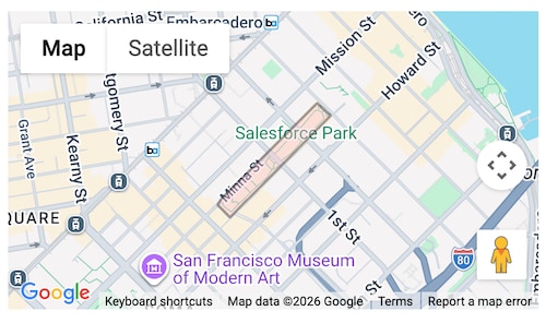
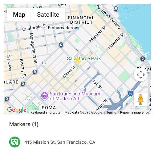
Displays a map with markers for one or more locations.
For Use In
Lightning Experience, Experience Builder Sites, Salesforce Mobile App, Lightning Out (Beta), Standalone Lightning App
lightning-map is a pilot or beta service that is subject to the Beta Services Terms at Agreements - Salesforce.com or a written Unified Pilot Agreement if executed by Customer, and applicable terms in the Product Terms Directory. Use of this pilot or beta service is at the Customer’s sole discretion.
Note
A lightning-map component shows a map of one or more locations, using geocoding data and mapping imagery from Google Maps.
The map image is shown in a container, with an optional list of the locations. The list is visible by default when multiple locations are specified. When you select a location title in the list, its map marker is activated. The list is shown beside or below the map, depending on the width of the container.
lightning-map loads content from the Salesforce domain maps.a.forceusercontent.com in an iframe. Allow maps.a.forceusercontent.com if you use this component in your own domain and you use the Content Security Policy frame-src directive, such as in Experience Builder sites or Lightning Out. For more information, see Content Security Policy in Experience Builder sites.
Pass the locations to the component’s map-markers property.
lightning-map implements the map blueprint in the Salesforce Lightning Design System (SLDS). The map adapts to SLDS 1 or SLDS 2 styling based on the org’s theme or the container app that you use.
map-markers is an array of markers that indicate location.
A marker contains map data:
Location Information: A coordinate pair of latitude and longitude, or an address composed of address elements to be geocoded.
Descriptive Information: Optional title, description, and an icon. These items are relevant to the marker but not specifically related to location.
Marker Properties
Use these marker properties to customize the map.
Property
Type
Description
location
object
Address elements (City, Country, PostalCode, State, and Street) to be geocoded, or a set of latitude and longitude coordinates. If you specify address elements and coordinates for one location, the map uses the coordinates. To support reliable geocoding of addresses, if you specify Street, you must also specify at least one of City, Country, PostalCode, or State.
title
string
Title text for the location, placed in the location list and in the info window when you click a marker. HTML tags aren’t supported and are shown as unescaped markup.
description
string
Text describing the location, placed in the info window when you click a marker or location title. A subset of HTML tags is supported. See Use HTML Tags in Descriptions.
icon
string
The icon that’s placed next to the location title in the list. Only Lightning Design System icons are supported. Custom icons are currently not supported in the location list. The default icon is standard:location. For more information, see Show Multiple Addresses and a Title.
value
string
An optional unique identifier for a marker. When you select a marker, its value is assigned to the selected-marker-value attribute.
type
string
A type of shape to use instead of the default map marker. Accepted values are Circle, Rectangle, and Polygon. See Mark Locations with Shapes.
HTML tags are supported for use with the description property. The supported HTML tags are b, br, del, em, h1, h2, h3, h4, h5,h6, i, ins, mark, p, small, strong, sub, and sup. Other HTML tags you pass to description are sanitized and removed.
This example formats some words in a marker description to make them bold and italicized.
1mapMarkers = [2{3 location:{4 Street: "1 Market St",5 City: "San Francisco",6 Country: "USA",7},8 title: "The Landmark Building",9 description: "Historic <b>11-story</b> building completed in <i>1916</i>",10},11];
Create a Single Marker
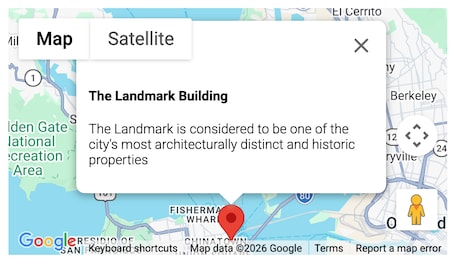
Here’s an example of a marker that uses address elements.
1import{LightningElement}from "lwc";23export default class LightningMapExample extends LightningElement{4 mapMarkers = [5{6 location:{7 City: "San Francisco",8 Country: "USA",9 PostalCode: "94105",10 State: "CA",11 Street: "The Landmark @ One Market, Suite 300",12},13 value: "location001",14 title: "The Landmark Building",15 description:16 "The Landmark is considered to be one of the city's most architecturally distinct and historic properties", //escape the apostrophe in the string using '17 icon: "standard:account",18},19];20}
Here’s an example of a marker that uses coordinates for latitude and longitude.
For each map marker in the array of map markers, provide either latitude and longitude coordinates or address elements to be geocoded. If you specify both in a single marker, latitude and longitude get precedence.
Show Multiple Addresses and a Title
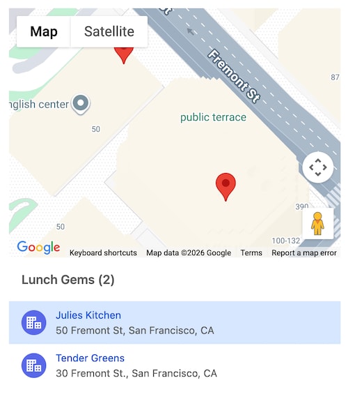
When you specify multiple markers in an array, the lightning-map component renders a list of tiles with location titles and addresses, with a heading that’s placed above the list.
Each location tile contains an icon, a title, and an address.
Specify the markers-title attribute for a custom heading for your locations. If you don’t pass this attribute, the heading is “Markers(n)” where n is the number of markers you provide.
To select a marker on load, use the selected-marker-value attribute. Retrieve the selected marker using the onmarkerselect handler.
To customize each location tile, you can specify the optional icon, title, and description properties. The lightning-map component appends the icon next to the address.
The description is shown in an info window when the user clicks the marker.
Get the selected marker using the event.target.selectedMarkerValue property.
1import{LightningElement, track}from "lwc";23export default class LightningMapExample extends LightningElement{4 mapMarkers = [5{6 location:{7 // Location Information8 City: "San Francisco",9 Country: "USA",10 PostalCode: "94105",11 State: "CA",12 Street: "50 Fremont St",13},1415 // For onmarkerselect16 value: "SF1",1718 // Extra info for tile in list & info window19 icon: "standard:account",20 title: "Julies Kitchen", // e.g. Account.Name21 description: "This is a long description",22},23{24 location:{25 // Location Information26 City: "San Francisco",27 Country: "USA",28 PostalCode: "94105",29 State: "CA",30 Street: "30 Fremont St.",31},3233 // For onmarkerselect34 value: "SF2",3536 // Extra info for tile in list37 icon: "standard:account",38 title: "Tender Greens", // e.g. Account.Name39},40];4142 selectedMarkerValue = "SF1";4344 handleMarkerSelect(event){45 this.selectedMarkerValue = event.target.selectedMarkerValue;46}47}
Show or Hide Locations
By default, the list of locations is hidden when you pass in a single marker and shown when you pass in multiple markers. To hide the list of locations for multiple markers, set list-view="hidden".
To show the list of locations for a single marker, set list-view="visible".
If you specify a type to show a shape at a location, the list view doesn’t show an entry for the location. See Mark Locations with Shapes.
The example for specifying zoom-level also uses list-view.
Specify Zoom Level
If you don’t specify the zoom-level attribute, the lightning-map component calculates a zoom level to accommodate the markers in your map.
To specify a particular zoom level, set zoom-level to a value corresponding to a Google Maps API zoom level. Currently, Google Maps API supports zoom levels from 1 to 22 in desktop browsers, and from 1 to 20 on mobile. For more information, see Zoom Levels in the Google Maps API documentation.
Here’s an example that uses zoom-level and list-view attributes.
The component’s JavaScript sets the markers, zoom level, and list view visibility.
1import{LightningElement}from "lwc";23export default class LightningMapExample extends LightningElement{4 mapMarkers = [5{6 location:{7 Street: "1000 5th Ave",8 City: "New York",9 State: "NY",10},1112 title: "Museum of Fine Arts",13 description:14 "A grand setting for one of the greatest collections of art, from ancient to contemporary.",15},16];17 zoomLevel = 15;18 listView = "visible";19}
Center the Map
When you have multiple map markers, the component centers the map on a location near the center of the markers by calculating the geometric mean.
Use the center attribute to specify a different location for the map’s center. You can specify latitude and longitude, or at least one of the address elements: Country, State, City, and PostalCode. Street is optional.
The center location format is the same as the map-markers location format. However, you can’t specify a title, icon, or description for the center.
Here’s an example that centers the map using latitude and longitude.
1import{LightningElement}from "lwc";23export default class LightningMapExample extends LightningElement{4 mapMarkers = [5{6 location:{7 Street: "1000 5th Ave",8 City: "New York",9 State: "NY",10},1112 title: "Metropolitan Museum of Art",13 description:14 "A grand setting for one of the greatest collections of art, from ancient to contemporary.",15},16{17 location:{18 Street: "11 W 53rd St",19 City: "New York",20 State: "NY",21},2223 title: "Museum of Modern Art (MoMA)",24 description: "Thought-provoking modern and contemporary art.",25},26{27 location:{28 Street: "1071 5th Ave",29 City: "New York",30 State: "NY",31},3233 title: "Guggenheim Museum",34 description: "World-renowned collection of modern and contemporary art.",35},36];3738 markersTitle = "Coordinates for Centering";3940 center = {41 location:{Latitude: "40.7831856", Longitude: "-73.9675653"},42};43}
The same map could use address elements to center:
1center = {2 location:{Street: "170 Central Park West", PostalCode: "10024"},3};
Show the Footer
The footer shows a link for opening the map in Google Maps in a new window or tab. By default, the first marker location opens. When viewing a map with multiple locations, select a location from the list before clicking the link to open that location in Google Maps.
The external Google map image shows a marker labeled with the location information that’s specified for the marker in lightning-map. The title and description aren’t included.
To show the footer, specify the show-footer attribute.
lightning-map enables you to specify which map controls to allow. Set the options attribute to
enable or disable map controls using these boolean properties.
Property
Default Value
Description
draggable
true
Enables dragging to pan the map with the mouse. Set to false to prevent dragging. This property affects the map only. Markers aren’t draggable.
zoomControl
true
Shows the +/- zoom controls on the bottom of the map. Set to false to remove the controls and prevent zooming.
scrollwheel
true
Permits zooming with the mouse wheel. Set to false to disable zooming with the mouse wheel when zooming is enabled. If zoomControl is false or disableDefaultUI is true, the scrollwheel setting has no effect because these settings disable zooming.
disableDefaultUI
false
Set to true to remove Map/Satellite and +/- zoom buttons. The satellite view and zooming are disabled. Mouse scrolling and dragging is not affected by disableDefaultUI.
disableDoubleClickZoom
false
Set to true to disable zooming with a mouse double-click when zooming is enabled.
Zooming behavior is influenced by all the properties except draggable.
To prevent all zooming, set zoomControl: false
To prevent all zooming and also remove the Map/Satellite buttons, set disableDefaultUI: true
To allow zooming, but prevent the scroll wheel from activating zoom, set scrollwheel: false
To allow zooming, but prevent a double-click from activating zoom, set disableDoubleClickZoom: true
This example disables dragging and also disables the default UI, which removes the zoom capability and
Map/Satellite button. The result is a static map.
The values of the options attribute are set in an object of boolean values in JavaScript.
1import{LightningElement}from "lwc";23export default class LightningExampleMapControls extends LightningElement{4 mapMarkers = [5{6 location:{7 Street: "1000 5th Ave",8 City: "New York",9 State: "NY",10},1112 title: "Metropolitan Museum of Art",13 description:14 "A grand setting for one of the greatest collections of art, from ancient to contemporary.",15},16];17 mapOptions = {18 draggable: false,19 disableDefaultUI: true,20};21}
Mark Locations with Shapes
lightning-map enables you to customize your maps to use different indicators
for locations instead of the default Google Maps markers.
The map-markers attribute supports the type property to define colored shapes to mark a location. Available type values are Circle, Rectangle, and Polygon. The values are
case-sensitive.
The type property works with these properties to define a shape’s appearance.
type Value
Property
Property Type
Description
Circle
radius
number
The number in meters for the radius of the circle. This value represents the Earth’s surface included in the circle around the location.
Rectangle
bounds
object
Uses north and south latitude values and east and west longitude values to specify the corners of the rectangle.
Polygon
paths
object
Defines a set of lat and lng properties for the latitude and longitude coordinates of the polygon’s shape.
All
strokeColor
string
Hexadecimal color code or CSS3 color name for the stroke, which creates the edge of the shape.
strokeOpacity
number
The degree of transparency of the stroke. The value is between 0.0 and 1.0, where 0.0 is transparent and 1.0 is opaque.
strokeWeight
number
The stroke width in pixels.
fillColor
string
Hexadecimal color code or CSS3 color name to fill the shape.
fillOpacity
number
The degree of transparency of the fill for the shape. The value is between 0.0 and 1.0, where 0.0 is transparent and 1.0 is opaque.
Mark a Location with a Circle
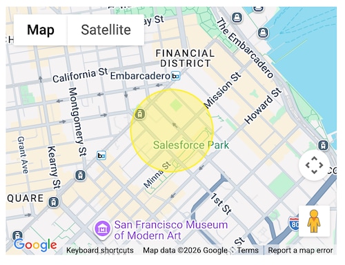
This example creates a yellow circle to mark the location.
The mapMarkers object defines the location and the type. The properties specified after type define
the circle as having a 200 meter radius, and a yellow color #FFF000 for both the stroke edge and fill, with the edge more opaque than the fill.
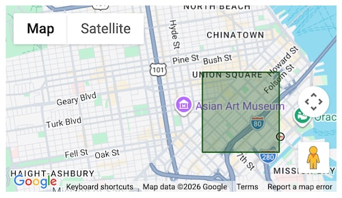
This example shows the JavaScript for defining a rectangle shape for a location.
The mapMarkers object sets the type to Rectangle. The bounds property defines the coordinates
of the rectangle for the location. Other properties define the characteristics of the stroke
and fill.
Pass the mapIcon property to the map-markers attribute to specify an SVG icon image in place of the Google Maps marker.
Use either type or mapIcon to customize a given location. You can’t use both for one location.
The mapIcon property works with the following properties to define the icon’s appearance.
Property
Type
Description
path
string
SVG path notation to add a vector-based symbol as the icon for a marker.
scale
number
The amount by which the marker icon is scaled in size. The default value is 1. The marker icon size is multiplied by the scale value to produce the actual output size of the marker in pixels.
anchor
Point
Coordinates used to align the marker to the map coordinates when the zoom level changes. The default anchor is (0,0) which can lead to the marker moving when you zoom out. Set the anchor coordinates to account for the width and height of the icon. For example, set the x value equal to half the image width and the y value equal to half the image height.
strokeColor
string
Hexadecimal color code or CSS3 color name for the stroke, which creates the edge of the custom icon.
strokeOpacity
number
The degree of transparency of the stroke. The value is between 0.0 and 1.0, where 0.0 is transparent and 1.0 is opaque.
strokeWeight
number
The stroke width in pixels. The default is 1.
fillColor
string
Hexadecimal color code or CSS3 color name to fill the icon.
fillOpacity
number
The degree of transparency of the fill for the icon. The value is between 0.0 and 1.0, where 0.0 is transparent and 1.0 is opaque.
This example creates a gold star without an outline as the marker. The list-view is made visible to show that a location with a custom marker is displayed in the list of markers.
The path creates a star that’s 245px x 230px. Use an SVG editor to determine the image size, which helps
determine the anchor coordinates needed. See MDN
for a list of SVG tools.
The anchor property sets the x coordinate to 122.5 which is half the width of the image, and sets the
y coordinate to 115 which is half the height of the image. For more information about the anchor property, see
Markers with vector-based icons
in the Google Maps Platform documentation.
The scale property sets the star to display at a comfortable size for the map viewed on a desktop.
The lightning-map component relies on data from Google for geocoding and mapping imagery. Inaccuracies or geocoding errors in the data can’t be fixed by Salesforce.
You can specify a maximum of 10 geocoded address lookups per map. Lookups for both the map-markers and center attributes count toward the limit of 10 geocoded addresses. To show more markers, provide location values using a pair of latitude and longitude coordinates, which don’t require geocoding. Address locations that exceed the geocoding limit are ignored.
We recommend limiting your map to 100 locations in total. For example, if you provide map markers for 5 geocoded addresses, you can provide up to 95 extra markers using latitude and longitude.
All latitude and longitude values must be valid. If you pass in an invalid latitude or longitude, the markers aren’t plotted on the map. Latitude values fall within -90 and 90, and longitude values fall within -180 and 180.
Also consider these guidelines:
If you specify an address, you must provide at least one of these values: City, PostalCode, State, or Country.
If you pass in both an address and a latitude and longitude, the map plots the marker according to the latitude and longitude values.
If a marker in the map-markers array is invalid, no markers are plotted on the map.
Usage Considerations
lightning-map uses the Google Maps Platform and is bound to its terms of service. The use of Google Maps Platform is prohibited in specific territories based on IP addresses. For more information, see Google Maps Platform Prohibited Territories. lightning-map is not supported in these territories and does not load correctly when accessed from the IP addresses associated with these territories. Users in these territories can continue to use Google Maps directly as detailed at Google Maps Platform Coverage Details.
Custom Events
markerselect
The event fired when a marker is selected. Select a marker by clicking it on the map or in the list of locations. The value of the selected marker is available on the selected-marker-value attribute on the component.
The markerselect event returns this parameter.
Parameter
Type
Description
selectedMarkerValue
string
The unique identifier of the currently selected marker.
The event properties are as follows.
Property
Value
Description
bubbles
true
This event bubbles up through the DOM.
cancelable
false
This event has no default behavior that can be canceled. You can’t call preventDefault() on this event.
composed
false
This event does not propagate outside the template in which it was dispatched.
Attributes
Name
Description
Type
Default
Required
center
A location to use as the map's center. If center is not specified, the map centers automatically.
object
list-view
Displays or hides the list of locations. Valid values are visible, hidden, or auto. This value defaults to auto, which shows the list only when multiple markers are present. Passing in an invalid value hides the list view.
string
auto
map-markers
One or more objects with the address or latitude and longitude to be displayed on the map. If latitude and longitude are provided, the address is ignored.
array
markers-title
Provides the heading title for the markers. Required if specifying multiple markers. The title is displayed below the map as a header for the list of clickable addresses.
string
options
Provides the list of map settings/options. The options contain different map settings with either true/false value.
Object
region
Sets the region for the map. Defaults to user locale. Possible values can be found in the "Region Code" column in table at https://developers.google.com/maps/coverage
selected-marker-value
Provides the value of the currently selected marker. Returns undefined if you don't pass value to map-markers.
String
show-footer
If present, the footer element is displayed below the map. The footer shows an 'Open in Google Maps' link that opens an external window to display the selected marker location in Google Maps. Default value is false.
Boolean
false
zoom-level
The zoom levels as defined by Google Maps API. If a zoom level is not specified, a default zoom level is applied to accommodate all markers on the map.